
Advocating for better cycling facilities can take a number of different forms. Everyone can be involved! Here are a few ways:
This is a list of known recent openings, re-openings, temporary shared path or popular cycling road closures around Western Sydney. Please contact us if you have any updates to these, or would like to let us know of other closures that aren't listed here.

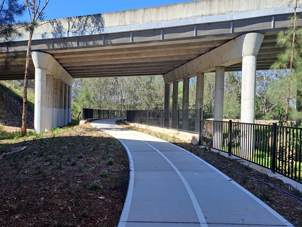
Location: Mavis St M7 underpass
Date: Nov 2023
Details: A section of shared path starting at the M7 shared path Mavis St Rooty Hill ramp and proceeding under the M7 alongside Angus Creek to the new Blacktown Exercise Sports and Technonlogy Hub (BEST) at the Blacktown International Sportspark, then onto Charlie Bali reserve.
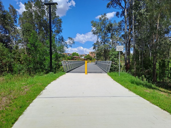
Location: Milson Park, Westmead.
Date: Nov 2023
Details: Milson Park masterplan (Shared path between Mons Rd and Darcy Rd, Westmead, following the Finleysons Ck corridor).
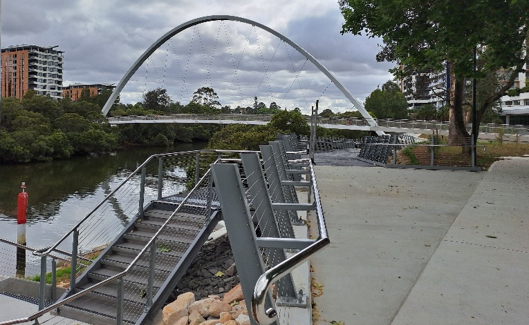
Location: Alfred St Bridge across the Parramatta River.
Date: 31st Oct, 2023
Details: See Parramatta Council's Alfred St Bridge page.
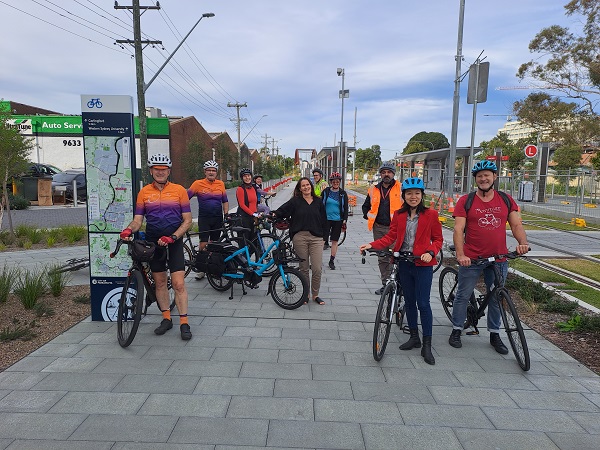
Location: 5.8km Parramatta Light Rail Active Transport Link (Shared Path) between the corner of Alfred St and River Rd West Parramatta, and Boundary Rd, Carlingford
Date: 31st May, 2023
Details: See the Project Active Transport Link Map.
Note: This was a 'soft' opening. Some of the access points are still not open. There are some diversions in place and other ongoing works.
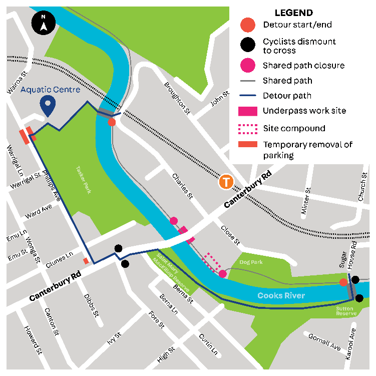
Location: The Canterbury Rd underpass on the Cooks River Shared Path is closed for upgrading. Detour in place. See position on Google Maps.
Reason: Underpass upgrade by Canterbury Bankstown Council.
Dates: After much delay, between Aug 26th 2022 until 'around May 2024'.
Details: Council's
Canterbury Town Centre Upgrade page. Some additional notes to the route below, thanks to James who
emailed the below comments:
The Council has helpfully installed a short temporary asphalt path through Tasker Park so cyclists
don't have to conflict with pedestrians using the Aquatic Centre entrance and carpark, they have
also linemarked Phillips Avenue in Canterbury with cycleway signs too. Another asphalt path has
also been installed next to the dog park in Close Street on the other side of Canterbury Road in
case people miss the detour or need to go to Canterbury Station/Town Centre.
Note: This is part of a popular cycling route between Strathfield and Wolli Creek, and being done as part of the Canterbury Town Centre upgrade.
Suggested Detour:
Location: Prospect Reservoir Shared Path between the Prospect Reservoir Picnic Area and Chandos Road. See the section on Google Maps.
Reason: Upgrade work on the Spillway bridge by Select Civil/Cardno on behalf of Water NSW.
Dates: Initially closed intermittently between April and July 2021, but works continued until September 2022.
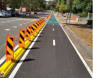
Location: 350m popup cycleway from Harris Park Station path to the M4 shared path, along Cambridge and Wigram Sts, Harris Park. See the Transport for NSW information brochure. There are now plans in place to convert this to a permenent installation.
Date: October 2021
Note: This is easier and safer than the previous route along Raymond and High Sts.
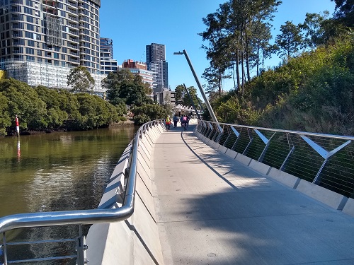
Location: Parramatta Escarpment Boardwalk Shared Path, opposite the Parramatta Ferry Wharf. See approximate alignment on Google Maps.
Date: April 1st, 2021
Note: This is a valuable 460m long addition to the Parramatta Valley Cycleway (shared path). It removes the need to climb the hill to cross Macarthur St at the zebra crossing, and makes navigation of the shared path a lot more straight-forward. See CAMWEST's Westmead to Concord West ride, which uses this section of path.
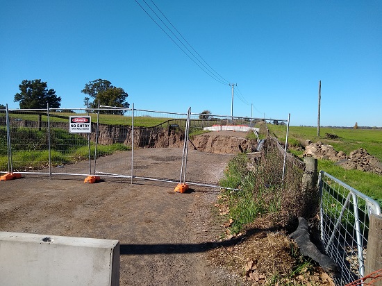
Location: Cornwallis Road in Cornwallis (Richmond Lowlands). See approximate position on Google Maps.
Reason: Section of road severely damaged by floods.
Dates: Closed March 2021. Further damage occurred in floods in 2022.
Updates: 2024 - See the Hawkesbury Council's Major Road Projects webpage for updates.
Note: This is part of a popular cycling route between Richmond and Windsor, along the Hawkesbury River. A shorter loop can still be completed, starting and finishing at Richmond, and doing a loop around the western half of the Lowlands.
There are several shared paths currently under construction or soon to start construction in the Parramatta and Blacktown areas. These include:
CAMWEST along with other bicycle groups, individuals, and government bodies submit comments when community consultation is sought on projects that affect cycling in our area. Below are some examples of what we and other organisations have submitted or been involved with.
Overview:The NSW State Govt have granted Cumberland Council over $770,000 to undertake detailed investigations on converting the disused 100 year old Pippita abatoir line between Lidcombe Station and Olympic Park into an active transport corridor. Although in poor condition, bridges already exist across Parramatta Rd and the M4. See this link to the video story from Seven News. While we would welcome the off-road link between Lidcombe and Olympic Park, without improved connectivity around Lidcombe we fear that the path may be a bit of a white elephant. I hope we're wrong.
2024 Masterplan documentation, article, and feedback:
Original documentation and feedback from 2022:
2022 Feedback from CAMWEST:Updated: Mar 2024
Overview: Bernera Rd is outside our traditional advocacy area. However we felt this missing link was strategically important for cycling in greater Western Sydney. Our concerns lay not with the project itself, but with access to the northern end of the Shared Path alongside Bernera Rd which is planned to be built as part of the project. We believe that the planned access to the path from the M7 Bernera Rd interchange is potentially dangerous. Along with several partial fix options, we suggest the only comprehensive option that we believe addresses all of our safety concerns.
Project Documentation: Feedback from CAMWEST and Bicycle NSW:Updated: Feb 2024
Overview: Although the contributions that replacing some shorter car journeys with cycling can make to the overall carbon emissions reduction target is small compared with some from other sectors, we thought it was important to highlight the contributions that the transport mode-shift could make.
Project Documentation: Feedback from CAMWEST:Updated: Jan 2024
Overview: This was a relatively short and quick piece of feedback. We welcome the routes put
forward in the plan which we believe will form part of the Active Transport backbone in the area.
One of the pinchpoints immediately outside the precinct (which wasn't raised in the feedback) is the
railway crossing on Bridge St. This is on the Cumberland and Parramatta council boundary and the bridge
is likely a State asset. A safe crossing will need to be part of the development of the route alongside
the railway line between Wentworthville and Westmead.
Updated: Dec 2023
Overview: An underlying issue that we've observed for all the Cumberland Council Town Centre Public
Domain Plans is that we're not aware of any 'mid-level' Active Transport plans that affect riders getting
into or through these precincts. Council have a broad LGA-wide plan, but it doesn't go into the
detail necessary for each of these important town centres.
This plan contains a few welcome linkages on the western side of the railway line, but lacks any clear
direction that would encourage Active Transport uptake in the area.
Updated: Dec 2023
Overview: An underlying issue that we've observed for all the Cumberland Council Town Centre Public
Domain Plans is that we're not aware of any 'mid-level' Active Transport plans that affect riders getting
into or through these precincts. Council have a broad LGA-wide plan, but it doesn't go into the
detail necessary for each of these important town centres.
This plan has a vague alternative to Guildford Rd (East) for riders who are less confident in traffic, but lacks any
clear direction that would encourage Active Transport uptake in the area.
Updated: Dec 2023
Overview: An underlying issue that we've observed for all the Cumberland Council Town Centre Public
Domain Plans is that we're not aware of any 'mid-level' Active Transport plans that affect riders getting
into or through these precincts. Council have a broad LGA-wide plan, but it doesn't go into the
detail necessary for each of these important town centres.
We've suggested that the railway line crossing needs serious consideration, and also suggested an additional on-road
alternative to Amy St for riders who are less confident in traffic.
Updated: Oct 2023
Overview: As a number of developments have recently occured or are planned, Parramatta have released a draft review of their 2017 Bike Plan. While we broadly welcome the ambitious plan, we believe there are a few deficiencies in there. We left comments on the ineractive map and also elaborated on some of them in our written feedback.
Project Documentation and Interactive Map: Feedback from CAMWEST and Bicycle NSW:Updated: Sep 2023
Overview: In late 2022 CAMWEST members provided comments on an initial interactive map of the area and attended a subsequent workshop on refining and further developing some of the ideas put forward. The end result is the Draft Walking and Cycling Strategy, to which both CAMWEST and Bicycle NSW have provided feedback. Unfortunately the plans as presented are still at a high 'concept' level, with more work required to identify potential usable routes. On the upside, two of the identified corridors already have more detailed plans in place. There is some movement on at least one of these - The Duck River Parklands.
Project Documention: Feedback from CAMWEST and Bicycle NSW:Updated: Aug 2023
Overview: Proposed Stage 3 of existing shopping precinct. As part of the project a shared path is proposed along the south side of Chruch St, Rooty Hill which will link the M7 shared path to Rooty Hill Rd South. A short path along Rooty Hill Rd South is also proposed between Church St and Beggs Rd. Promotional documentation suggests that path will continue along Rooty Hill Rd South to the Great Western Hwy, but this is outside the Stage 3 area and the the plans don't indicate this. Bike parking is proposed in Stage 3, but probably not where riders want it. CAMWEST have made a number of suggestions relating to cycling access to Stage 3 as well as the existing two stages and links into the surrounding community.
The project documentation and submissions can be found at:
Submission from CAMWEST:Updated: April 2023
Overview: The plan covers improvements to four identified precincts which make up Lidcombe Town Centre. A separated path is proposed along Mary St on the north side of the railway line, but this is the main real active transport improvement. (Note that the Pippita Rail Trail is proposed to end somewhere along Church St as well). CAMWEST make several other suggestions that we believe would improve Active Transport in the area. However, we believe that until the elephant in the room - the crossing of the railway line at or near Lidcome station - is adequately addressed, any other improvements will be just fiddling around the edges.
The project documentation can be found at:
Submissions from CAMWEST and BicycleNSW:Updated: April 2023
Overview: Two options were presented to convert the Wigram St popup to a permanent cycleway with additional streetscape improvements. Consultation closed on 28th Feb, 2023. 95 responses were received by council. Emergency Services have raised concerns about the preferred option. A third alternative solution is now being investigated by council. More updates will be posted here when received. Project details below:
Original: Feb 2023. Last Update: Aug 2023.
See comments on the Transport for NSW Interactive map below.
Updated: Jan 2023
As part of the NSW Government's Greater Cities Commission, Transport for NSW have been working on Strategic Cycleway Corridors for three of the six identified 'cities' that form the Greater Sydney area.
Bicycle NSW, CAMWEST and other Bicycle User Groups have been assisting Trasnport for NSW with identifying corridors for the above cities. Although broad in scope, these corridors will help inform Transport for NSW as they plan new cycling infrastucture going forward.
Overview: This is the latest review of shared paths and active transport in general for the Penrith LGA.
Summary of CAMWEST Feedback:
The project documentation can be found at:
Updated: Oct 2022
Overview: Cumberland Council are proposing to update existing paths in this corridor and build others, including bridges across Wellington Rd and two bridges across the Duck River between Boundary Rd and Princes Rd West and near Chiswick Rd. There were some existing paths missing from Council's base map. CAMWEST would like to see the first of the above crossings of Duck River given priority, as this would provide a much needed on-road link to the south. Note there is also a planned connection to the Pipeline path when that gets constructed.
The project documentation can be found at:
Submissions from CAMWEST and Bicycle NSW:Updated: Oct 2022
Overview: Cumberland Council are planning to update the existing path between Prospect Reservoir and Railway St Guildford (referred to as Corridor West), and continue the shared path through the pipeline reserve to Rose Crescent near Regents Park station (Corridor East). The centre-piece of Corridor East will be the construction of a bridge across Woodville Rd. There are also planned connections to the Duck River path and other local streets. CAMWEST make several suggestions for additional improvements to Corridor West.
The project documentation can be found at:
Submissions from CAMWEST and Bicyle NSW:Updated: Sep 2022
Overview: This project is for widening the Westlink M7 Motorway between Prestons and Richmond Rd to three lanes in each direction. The M7 and M12 interchange near Elizabeth Drive is also being managed by this project. Note that the section of the M7 around the M4 interchange is being managed under a separate project. There are a number of shared path deviations planned during construction, ranging in additional distance per segment from 300 metres to 1.3 kms (Exec Summary Page 12). Apart from some changes around the M12 interchange, the original path should be restored on completion of each stage.
Although we share concerns raised by others regarding using the third lane for general transport use where it was originally envisaged that any future lanes should be dedicated for public transport use, our concern now is to ensure that the shared path deviations during the construction phase are to the highest standard.
Note that after completion, cyclists will no longer have the option of riding on the M7 roadway between the M5 junction (Prestons) and Richmond Rd (See Exec Summary page 12). All riders will need to use the shared path. One small win for active transport users is that the M7 access path to Station St/North Parade at Rooty Hill alongside the northern side of the railway line will be sealed.
The project documentation and a copy of all submissions including the Submissions Report can be found at:
Original: Aug 2022. Last Update: June 2023